
Geology of Chaîne des Puys - France
Located in the heart of the Massif Central, the Chaîne des Puys is an alignment of single-gene volcanoes ranging in age from 6,900 to 95,000 years ago. It constitutes an exceptional natural laboratory for the study of continental volcanism and the tectonics associated with the extension of an intracontinental rift. This unique landscape, shaped by thousands of years of volcanic activity, was inscribed as a UNESCO World Heritage Site in 2018. This article explores the different types of volcanism present there, the geodynamic context that led to its formation, and the reasons for its World Heritage designation.
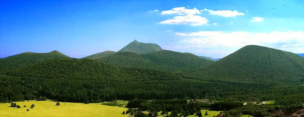
Photo : Panorama of the central part of the Chaîne des Puys from the Puy des Gouttes © Rémi Bornet
A bit of history :
The Chaîne des Puys, located in Auvergne, played a fundamental role in the scientific debates of the 18th and 19th centuries on the formation of the Earth and the origin of volcanic rocks. At that time, geology was still a nascent science, and two opposing theories fiercely contested each other: Neptunism, championed by Abraham Gottlob Werner, and Plutonism, initiated by James Hutton.
Neptunism, inspired by the observation of rock strata, postulated that all rocks, including basalts, were formed by the precipitation of minerals in a primitive ocean that covered the Earth. According to Werner and his followers, these rocks were sedimentary deposits or, in some cases, the product of the combustion of organic matter buried underground. This view ruled out any volcanic origin for basalts, which were considered ancient marine sediments transformed by chemical processes.
In contrast, plutonism, developed by James Hutton in his Theory of the Earth, argued that the Earth's internal heat played a key role in rock formation. For Hutton and his followers, basalt resulted from the eruption of magma from deep within the Earth, a phenomenon still active through contemporary volcanoes. He saw these formations as evidence that the Earth was a dynamic, constantly evolving system, and not simply a mere accumulation of ancient deposits.
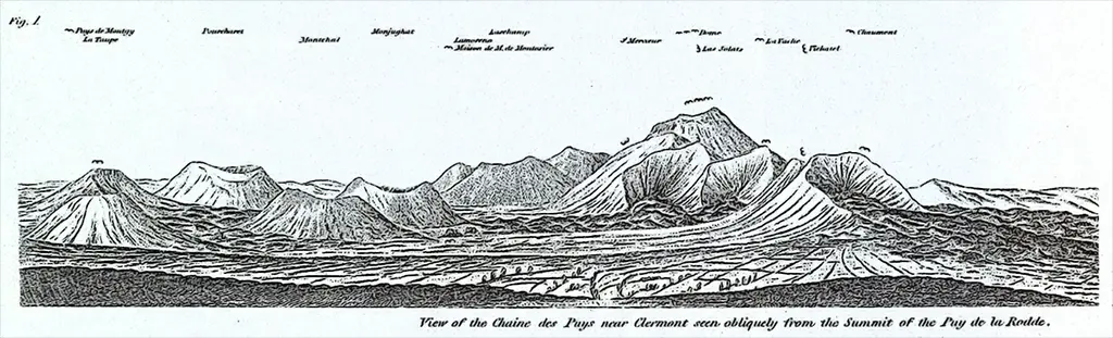
In this context of controversy, the extinct volcanoes of Auvergne, and particularly those of the Chaîne des Puys, became a prime area of study for distinguishing between these two worldviews. As early as 1752, the naturalist Jean-Étienne Guettard was the first to identify the volcanic nature of the region by observing the presence of basalt formations similar to those observed on active volcanoes. This hypothesis was further explored by Nicolas Desmarest in 1771, who precisely demonstrated that the Auvergne basalts originated from ancient lava flows. He provided irrefutable evidence, including the observation of burnt soil beneath the flows, as well as the lateral continuity between the columnar basalts and the superficial scoria of the same lavas.
These discoveries posed a challenge to Neptunism, but the intellectual battle did not end there. Figures such as Montlosier, a fervent defender of plutonism, traveled the region and even invited Neptunist geologists to come and observe the facts on site. One of the major arguments put forward by proponents of plutonism was the striking resemblance between the Auvergne volcanoes and those still active in Italy or Iceland, where the genesis of the basalts was beyond doubt. For his part, Déodat de Dolomieu, a French geologist and volcanologist, drew similar conclusions based on his observations of Sicilian and Italian volcanoes. He postulated the existence of a hot, viscous material beneath the Earth's crust, capable of forming basalts through solidification after eruption.
The controversy between Neptunists and Plutonists lasted several decades, fueled by heated debates and verbal sparring that demonstrated the importance of these questions for understanding Earth's history. With the publication of the first treatises on volcanology, the Neptunist theory gradually lost ground. The observations accumulated in Auvergne and elsewhere eventually established the idea that basalts were indeed of magmatic origin, thus putting an end to a scientific dispute that had divided the geological community.
Formation and geodynamic context :
The Limagne, located to the east of the Chaîne des Puys, is a graben (rift basin) that gradually formed as a result of tectonic extension. During the Oligocene, the Earth's crust stretched, causing the collapse of the central block and the formation of normal faults, including the Limagne Fault, which marks the western boundary of this basin. The latter was then filled with sedimentary deposits of lagoon and fluvial origin, reaching up to 2,000 meters thick. This fault also allowed the formation of numerous thermal springs, such as those of Royat and Châtel-Guyon, which still bear witness to the region's residual hydrothermal activity today.
The Limagne basin evolved under the effect of the gradual uplift of the Massif Central and the erosion that exposed the sedimentary deposits. Today, it presents a contrasting relief between the Limagne plain, where lacustrine and fluvial deposits remain, and the volcanic reliefs of the Chaîne des Puys, which dominate to the west.
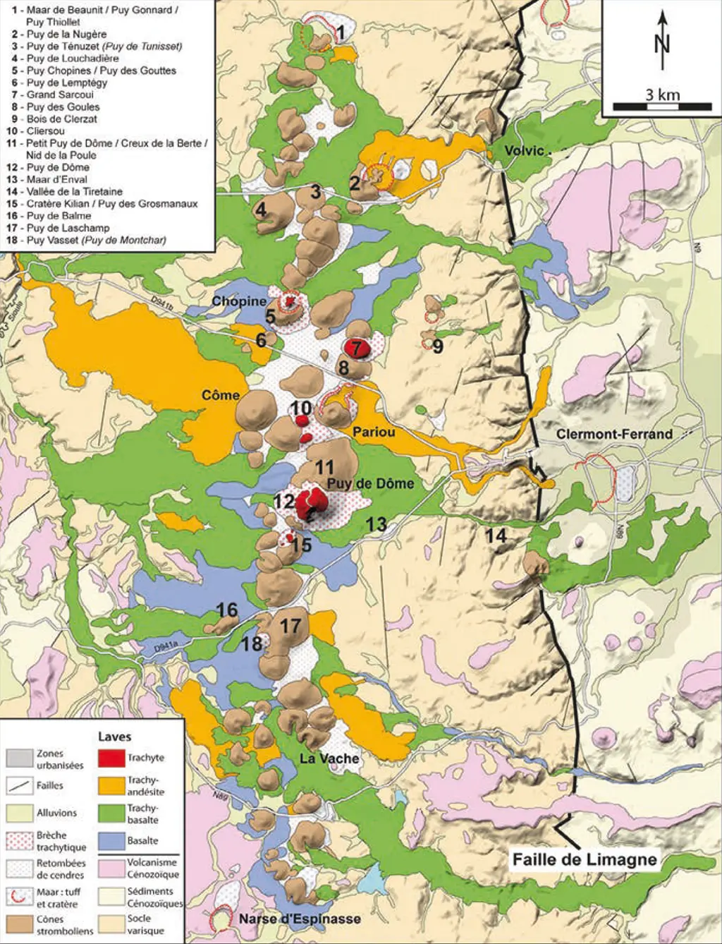
Document : Geological map of the Chaîne des Puys according to Portal et al. (2016)
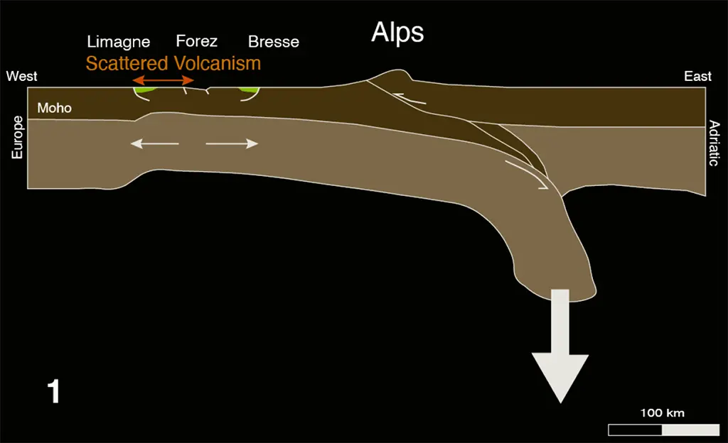
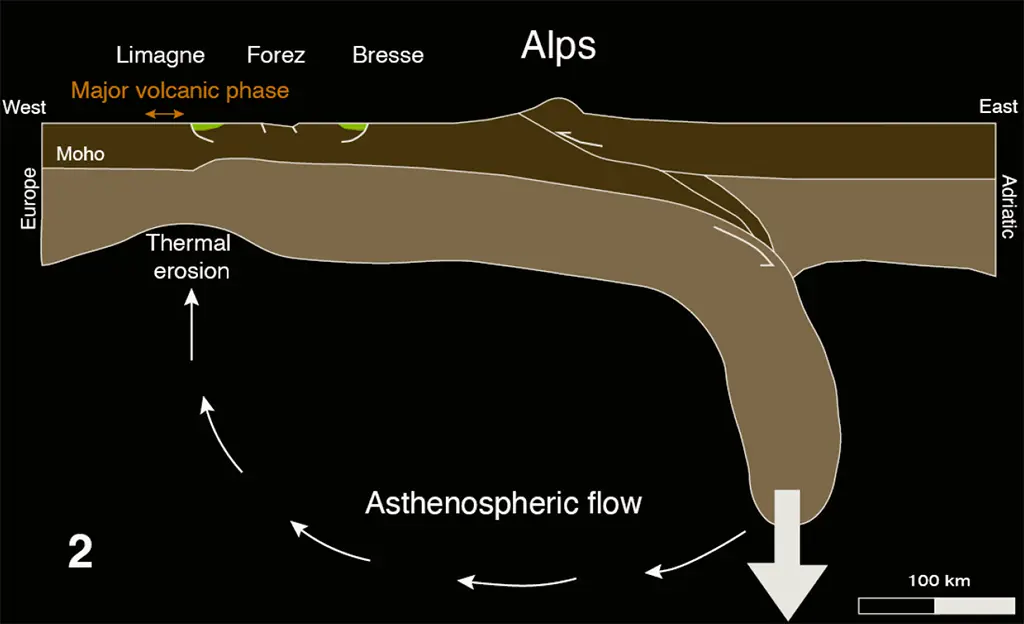
Active or passive rift ?
Two main theories explain the origin of the West European Rift and the formation of the Limagne :
- The active rift model assumes that a hot mantle plume rose beneath the region, causing a bulge in the crust before its collapse into a graben. This hypothesis is supported by the presence of thermal anomalies beneath the Massif Central, suggesting a significant mantle input. The formation of the lithospheric root beneath the Alps is thought to have played a role in the orientation of this plume, inducing complex mantle movements. However, there is no direct ascent of magma from this plume. Instead, the tectonic extension caused by the collapse of the bulge leads to adiabatic decompression of the upper mantle (without heat input), which promotes the partial melting of peridotites and the generation of magma that triggers the Chaîne des Puys eruptions.
- The passive rift model suggests that Alpine compression led to crustal stretching to the west, favoring the formation of the Limagne through gravitational collapse. This theory is based on the fact that extension occurred in response to broader tectonic forces, and not to an upwelling of hot material. In this context, volcanism in the Chaîne des Puys would be a secondary consequence of lithospheric decompression and melting of the underlying mantle.
Geophysical studies conducted in the region show that these two processes may have acted together, with the extensional context favoring the upwelling of hot mantle material and the generation of localized volcanism, as evidenced by the alignment of volcanic edifices in the Chaîne des Puys.
The different types of volcanism :
The Chaîne des Puys is distinguished by the great diversity of its volcanic forms. The volcanoes that compose it are monogenic, meaning they have experienced only a single eruption, unlike stratovolcanoes like the Plomb du Cantal, which result from multiple successive eruptions. This difference highlights the variability of the magma. These volcanic structures illustrate the geological evolution of the region and provide valuable insight into the mechanisms of intraplate volcanism.
Strombolian cones and their lava flows :
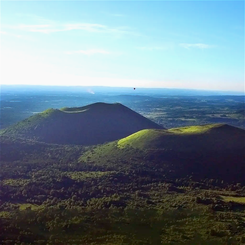
Strombolian cones are the most common volcanic formations in the Chaîne des Puys. They result from moderate to effusive eruptions of relatively fluid basaltic magma. These eruptions are characterized by the projection of incandescent lava magmas that fall around the point of eruption, forming a cinder cone.
These structures are often associated with lava flows that can travel several kilometers before solidifying. These flows have left their mark on the landscape by creating basaltic plateaus and lava fields called cheires, such as the Cheire de Côme. The Puy de Pariou is an emblematic example of this type of volcanism, with its well-preserved crater and symmetrical cone.
The activity of Strombolian cones in the Chaîne des Puys spans several thousand years, with repeated eruption phases that have contributed to the structuring of the current relief.
Maars :
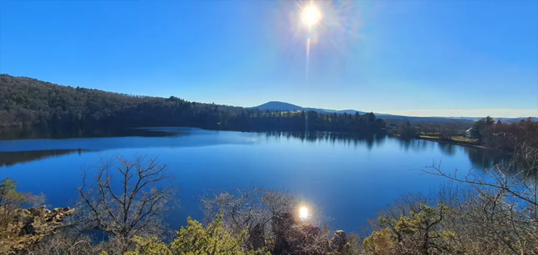
Maars are volcanic formations resulting from phreatomagmatic eruptions, violent interactions between magma and groundwater. When magma encounters a water table, the sudden vaporization of the water triggers a series of explosions that fragment the surrounding rock and project volcanic material over great distances.
These explosions excavate a large crater that can then fill with water and form a lake such as the Gour de Tazenat. In the Chaîne des Puys, several maars bear witness to this type of volcanic activity, although some have been covered by more recent deposits or urban development (such as the Clermont-Ferrand maar).
Lava domes :
Lava domes are formed by the extrusion of highly viscous, silica-rich magmas, such as trachytes. Unlike fluid basalt flows, these magmas flow very slowly and tend to accumulate around the point of eruptions, forming massive, steep edifices.
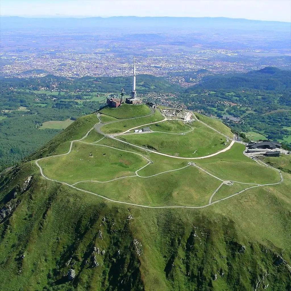
The Puy de Dôme is the most emblematic example of this type of volcanism in the region. Its formation took place around 11,000 years ago, with a gradual rise of magma that gave rise to an imposing structure. These eruptions can sometimes be accompanied by explosive phases if the pressure of the trapped gases becomes too great, generating pyroclastic flows and pyroclastic flows.
Lava domes are valuable witnesses to the magmatic differentiation processes that occur in the Earth's crust, and they contribute to the morphological diversity of the Chaîne des Puys.
UNESCO classification : international recognition
The inscription of the Chaîne des Puys as a UNESCO World Heritage Site in 2018 marks the recognition of its geological and scientific importance. This designation is based on several criteria that underscore the uniqueness and educational value of this site.
An exceptional illustration of continental rifting :
The Chaîne des Puys and the Limagne Fault constitute a remarkable example of the process of crustal thinning within an intracontinental rift. This site allows for the observation of the interactions between tectonics and volcanism on a small scale that is representative of large rifting systems.
The alignment of the volcanoes, the diversity of eruptive forms, and the relationship with the Limagne Fault offer a unique model for understanding the dynamics of continental divergence zones. Many researchers use the Chaîne des Puys as a field of study to better understand the processes at play in similar contexts around the world.
An exceptional volcanic landscape :
Beyond its scientific interest, the Chaîne des Puys is a natural site of remarkable beauty. The well-preserved volcanic landforms display a variety of shapes and colors, making it a unique landscape in Europe. Visitors can observe well-preserved craters, spectacular lava fields, and majestic domes, testifying to the site's geological richness.
Promoting this heritage requires the development of responsible tourism, combining the discovery of volcanism with environmental preservation. Structures such as Vulcania, the Puy de Dôme, and the Lemptégy Volcano welcome hundreds of thousands of visitors each year, contributing to the dissemination of knowledge about geology and volcanology.
A natural laboratory for Earth sciences :
The Chaîne des Puys is a veritable open-air laboratory for geoscience researchers. The studies conducted at this site explore fundamental questions about volcano formation, rift evolution, and the mechanisms of magmatic activity.
The data collected not only serve to improve our understanding of volcanism, but also to refine monitoring models for active volcanic zones around the world. Monitoring seismic and thermal activity in the region contributes to natural hazard prevention and the development of sustainable land management strategies.
Conclusion
The Chaîne des Puys is an exceptional geological site, providing unique insights into volcanic and tectonic processes in a continental environment. Its inclusion as a UNESCO World Heritage Site underscores the importance of its preservation and enhancement.
This landscape, shaped by millennia of volcanic activity, is a privileged field of study for scientists and a fascinating place of discovery for the general public. Between conservation and accessibility, the challenge today is to reconcile the protection of this natural heritage with its educational and tourism role, in order to pass on to future generations a site of inestimable value.
References :
MERLE et al. (2023) : "The UNESCO World Heritage Site of the Chaîne des Puys–Limagne Fault Tectonic Arena (Auvergne, France)", Geosciences, 13(198).
PORTAL et al. (2016) : "Cent ans de géophysique éclairent la Chaîne des Puys", Revue d'Auvergne